


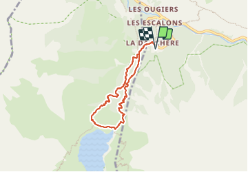
Lac du Lauvitel Parc des Écrins

GioA10
User

Length
6.7 km

Max alt
1542 m

Uphill gradient
550 m
Km-Effort
14 km

Min alt
990 m

Downhill gradient
551 m
Boucle
Yes
Creation date :
2023-06-10 07:11:36.0
Updated on :
2023-06-10 11:46:09.944
3h29
Difficulty : Easy

FREE GPS app for hiking
 SityTrail
IGN / Geographical institutes
SityTrail Plus
The world is yours!
About
Trail Walking of 6.7 km to be discovered at Auvergne-Rhône-Alpes, Isère, Les Deux Alpes. This trail is proposed by GioA10.
Photos


Positioning
Country:
France
Region :
Auvergne-Rhône-Alpes
Department/Province :
Isère
Municipality :
Les Deux Alpes
Location:
Vénosc
Start:(Dec)
Start:(UTM)
269792 ; 4985746 (32T) N.
Comments